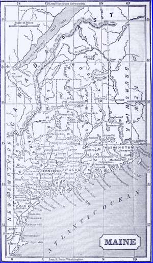
Aroostook County Maine
For our visitors we have provided
information available on our site, but all applies to Aroostook
County Maine. There are many places on the web where you will be
able to find additional information, but we didn't want you to
go away not finding any information for your search. This county
like many of our counties is up for adoption. Please let us know
if you are interested, just click the button


Aroostook War
Volunteers
More to come soon
Aroostook, County, Maine, in the north east part of the
state, is a long county, extending to the Canada line, and
unsettled in its north part. Watered by Madawaska River,
Aroostook River, and Matawamkeag River, and branches. Its waters
flow partly into St. John's River, and partly into the
Penobscot. There were in 1840, neat cattle 6,109, sheep 9,905,
swine 4,303; wheat 41,982 bush, produced, oats 36,518, buckwheat
21,912, potatoes 108,554; 20 stores, capitol $13,029; 2
tanneries, 2 flouring mill, 13 grist mill, 13 saw mills. Capitol
in manufacturing $12,800. 28 schools 1,150 scholars. Population
9,413. (Source: A
Complete
Descriptive And Statistical Gazetteer Of The United States
Of America, By Daniel Haskel, A. M and J. Calvin Smith,
Published By Sherman & Smith, 1843)
Aroostook River, Maine,
rises in the east part of Piscataquis County, separated by high
lands from the head waters of the Penobscot, which are not more
than 20 miles distant. Several ponds connect with its head
waters; its course is circuitous, to the north east and east
until it falls into the St. John's in New Brunswick. A road
passes from Bangor to Fort Fairfield on this river, near the
east boundary of the United States. The lands on this river are
very fertile, and are said to equal the best lands in the state
of New York for the culture of wheat.
(Source: A
Complete
Descriptive And Statistical Gazetteer Of The United States
Of America, By Daniel Haskel, A. M and J. Calvin Smith,
Published By Sherman & Smith, 1843)
Aroostook, County in
Maine, embracing the North East part of the state. Area about
5,000 square miles Pop. 30,240 in 1860, 22,479. The St. John R.
flows through the West part and then forms the North boundary of
the County It is drained by tributaries of this River, as the
Allegash River, Fish River and Aroostook River, and a large
number of small creeks. The Mattawamkeag River, a tributary of
the Penobscot River, drains the South part. The surface is
generally high and hilly; the valley of the upper course of the
St. John River is the lowest part. Mars Hill, near the East
boundary, is probably the highest point. The county abounds in
lakes. The Eagle Lakes are in the North East portion, and Grand
Lake washes the South East corner. The County is covered with
extensive forests, which yield valuable timber. The soil of the
River valleys is very fertile; but the climate is severe. The
settlements are in the South parts only. Honlton is the county
seat. Agricultural productions in 1870: Wheat, 46,916 bushels;
rye, 2,553 bushels; Indian-corn, 4,242 bushels; oats, 532,151
bushels; Irish potatoes, 380,701 bushels; butter, 523,510
pounds; hay, 48,052 tons. Cash value of farms, $3,010,130.
Total, estimated, value of all farm productions, including
additions to stock, etc., $1,845,600. Value of manufactures,
$607,283. (Source The Centennial
Gazetteer of the United States, by A. Von Steinwehr, J. C.
McCurdy & Company, 1871)
Houlton, Postal Town, capital of
Aroostook County, Me., 120 north north east Bangor, 196 north
east Augusta, 791 W. It borders New Brunswick on the East Stages
run on a excellent road, 3 times a week, to Bangor. Watered by
Meduxnekeag River, a branch of the St. Johns River. The soil is
fertile, adapted to wheat. A garrison is located 1 mile north of
the valley. There are in the town, 9 stores, capitol, $9,950; 2
lumber yards, capitol, $20,000; 2 tanneries, 1 flouring mill, 1
grist mill, 4 saw mill. Capital in manufacturing $7,900, 4
schools 144 scholars. Population 1,597.
(Source: A
Complete
Descriptive And Statistical Gazetteer Of The United States
Of America, By Daniel Haskel, A. M and J. Calvin Smith,
Published By Sherman & Smith, 1843)
 |
 |
| Source: Fannin Gazetteer |
Source: Fannin Gazetteer |
Maine Towns ~ Aroostook County
Amity, Postal Village., Aroostook
County, Maine, 210 north east Augusta, 805 W. It has 1 grist
mill, 1 saw mill, 2 school 77 scholars. Pop. 169.
(Source The Centennial Gazetteer of
the United States, by A. Von Steinwehr, J. C. McCurdy & Company,
1871)
Monticello, t., Aroostook County, Maine. It
has 1 saw mill. (Source: A
Complete
Descriptive And Statistical Gazetteer Of The United States
Of America, By Daniel Haskel, A. M and J. Calvin Smith,
Published By Sherman & Smith, 1843)
Weston, p-t., Aroostook co., Me., 259 n.
e. Augusta, 824 W. It is a half township, granted to Hampden
Academy. Drained by branches of Mattawamkeag r. Chartered in
1835. The soil is fertile, adapted to grain. It has 1 saw m., 2
sch. 95 scholars. Pop. 249. (Source:
A
Complete Descriptive And Statistical Gazetteer Of The United
States Of America, By Daniel Haskel, A. M and J. Calvin Smith,
Published By Sherman & Smith, 1843)
Allagash
Amity
Ashland
Bancroft
Benedicta Township
Blaine
Bridgewater
Caribou
Cary Plantation
Castle Hill
Caswell
Chapman
Crystal
Dickey[4]
Cyr Plantation
Dyer Brook
Eagle Lake
Easton
Fort Fairfield
Fort Kent
Frenchville
Garfield Plantation
Glenwood Plantation
Grand Isle |
Hamlin
Hammond
Haynesville
Hersey
Hodgdon
Houlton
Island Falls
Limestone
Linneus
Littleton
Ludlow
Macwahoc Plantation
Madawaska
Mapleton
Mars Hill
Masardis
Merrill
Monticello
Moro Plantation
Nashville Plantation
New Canada
New Limerick
New Sweden |
Oakfield
Orient
Oxbow (plantation)
Perham
Portage Lake
Presque Isle
Reed Plantation
Saint Agatha
Saint Francis
Saint John Plantation
Sherman
Silver Ridge Township
Smyrna
Stockholm
Van Buren
Wade
Wallagrass
Washburn
Weeksboro
Westfield
Westmanland
Weston
Winterville Plantation
Woodland |
This county like many of our counties is
up for adoption. Please let us know if you are interested, just
click the button
AHGP Maine
|